Tuesday, May 31, 2011

Bunaken,. The Charm of a Garden Paradise Under The Sea

The beauty of flora and fauna below the surface of the Bunaken Marine Park in the Bay of Manado, North Sulawesi, Indonesia indeed has worldwide. No wonder, Bunaken Marine Park is often known as the underwater paradise

Bunaken Marine Park in Manado Gulf at the expanse of the sea area of ​​887.5 hectares. Beneath the surface of the sea, there are about 200 species of fish. Start the Neon fish, Butterfly fish, Coral fish, Napoleon fish, and so forth. In addition there are various shapes and colors of coral reefs and other marine biota.

The beauty of the fauna was added again, the existence of the caves, tunnels, curves and crevices. There's even an appeal that is rarely found in other places is an impairment in the cliff wall.

To enjoy the beauty of the underwater surface of the Bunaken Marine Park, could use a semi-submersible vessel found off the coast of Bunaken Island. The semi-submersible vessel in which there are walls of glass. Dindin Through-wall glass, could menikmat kehdiupan and beauty beneath the sea. Good variety of fish, coral reefs, and other marine biota.

If you want a closer look at the beauty of the underwater surface of Bunaken, is better when diving. There are 23 places snorkeling or diving.
No less interesting is also the beauty above sea level, as well as complement the beauty of Bunaken Marine Park which is below sea level. One is the five islands surrounding the area of ​​Bunaken Marine National Park. Each island of Bunaken, Siladen, Manado Tua, Nain and Mantehage. On the island there Mantehage Bajo tribe.

Bunaken Marine Park is approximately 75 nautical miles from Beach City, Manado. It took about one hour by using a small boat equipped with two-engine boat. Rent is Rp. 800.000, - for at least 15 people up to a maximum of 25 passengers.


Foreign tourists began to arrive in droves to enjoy the underwater beauty of Bunaken. From year to year has increased. Especially after the Sail Bunaken 2009 was held, a sharp increase.

If in 2008 visited by 32,760 foreign tourists, then in 2009 increased to 51 000 foreign tourists. In fact, the North Sulawesi Provincial Government is targeting the year 2010 this brave as much as 100,000 foreign tourists arrived in Bunaken.

You feel interested in it ???... The immediate future and enjoy the beauty of Bunaken Marine Park ..


Prambanan Temple

Prambanan is a stunningly beautiful building built in the 10th century during the reign of two kings, and Rakai Rakai Pikatan Balitung. Rose as high as 47 meters (5 meters higher than Borobudur temple), the foundation of this temple has fulfilled the desire to show Hindu triumph in the land of Java. This temple is located 17 kilometers from the city center, in the middle of an area that now functions as beautiful park.

There is a legend that Javanese people always tell about this temple. Once, a man named Bandung Bondowoso loved Roro Jonggrang. Because of his love, Jonggrang asked Bondowoso make 1000 temples with statues in one night.

The request was nearly fulfilled Jonggrang asked the villagers to pound rice and make a big fire that created an atmosphere like the morning. Bondowoso who only completed 999 statues cursed Jonggrang be a statue of the 1000 because he felt cheated.
Prambanan temple has three main temples in the primary yard, namely Vishnu, Brahma, and Shiva. The three temples are a symbol of Trimurti in Hindu belief. All of them face east. Each main temple has accompanying temple facing to the west, namely Nandini for Shiva, Swan to Brahma, and Garuda for Vishnu. In addition, there are 2 temples wedge, 4 color temples and 4 corner temples. In the second there are 224 temples.

Entering the Shiva temple located in the middle and the highest building, you will find a room 4. One main room contains a statue of Shiva, while the other 3 rooms each containing a statue of Durga (Shiva's wife), Agastya (Shiva's teacher), and Ganesha (Shiva's son). Durga is touted as the statue of Roro Jonggrang in legend as told in atas.Di Vishnu temple is located in the north of Shiva temple, you will only see one room containing a statue of Vishnu. Brahma temple is located south of Shiva temple, you will only find one room with a statue of Brahma.

Quite attractive accompanying temple is Garuda temple that is located near the Vishnu temple. This temple keeps a story of half-bird human being named Garuda. Garuda is a mystical bird in Hindu mythology, who was gold, white face, red wings, beak and wings like eagles. It is estimated, the figure is Hindu adaptation of Bennu (means 'rises' or 'shining', usually associated with the god Re) in ancient Egyptian mythology or Phoenix in Old Greek mythology. Garuda succeeded in saving his mother from the curse of Aruna (Garuda is born handicapped brother) by stealing Tirta Amrita (holy water of the gods).

The ability to save that which was admired by many people until now and used for various purposes. Indonesia used it to sign the country. That said, the creator of the emblem of Garuda Pancasila find inspiration in this temple. Other countries also use it to sign the country is Thailand, with the same reason but the adaptation of different shape and appearance. In Thailand, Garuda is known as Pha Krut or Krut.Prambanan also has panels of relief describing the story of Ramayana. According to experts, the relief is similar to the Ramayana story is revealed through oral traditions. Another interesting relief is Kalpataru tree that the Hindu religion is considered as a tree of life, sustainability and environmental compatibility. In Prambanan, relief of Kalpataru tree is described middle flanking a lion. The existence of this tree makes experts consider that the people of the 9th century had wisdom to manage its environment.

Just as the figure of Garuda, Kalpataru is now also used for various purposes. In Indonesia, Kalpataru became a symbol of Forum for Environment (WALHI). In fact, some scientists in Bali to develop the concept of Tri Hita Karana for environment conservation by seeing Kalpataru relief in this temple. The tree of life can also be found on the mountains that used to open the puppet arts. A proof that the relief panels in Prambanan has worldwide.

If careful, you can also see various birds relief, this time a real bird. Bird reliefs at Prambanan are so natural that biologists can identify their genus. One was relief of the Yellow-crested Cockatoo (Cacatua sulphurea) that invite questions. Why, the bird was actually found only in Masakambing Island, an island in the Java Sea. Then, whether the type that were once numerous in Yogyakarta? The answer please find out for yourself. Because, until now no one who can solve the mystery.


Atlantis in Indonesia???


Successive natural disasters suffered by Indonesia. Starting from the tsunami in Aceh to the latest hot mudflow in East Java. It reminds us of similar events in the area known as the Continent of Atlantis. Is there a relationship between Indonesia and Atlantis?

Plato (427-347 BC) stated that tens of thousands of years ago there was a variety of volcanic eruptions simultaneously, causing earthquakes, melting ice, and flooding. The incident resulted partly submerged the earth's surface. That part is called the lost continent or Atlantis.

Recent research conducted by Aryso Santos, asserted that Atlantis was the region now called Indonesia. After doing research for 30 years, he produced a book Atlantis, The Lost Continent Finally Found, The Definitifve Localization of Plato's Lost Civilization (2005). Santos displays the 33 comparisons, such as area, climate, natural resources, volcanoes, and farming methods, which ultimately concluded that Atlantis is Indonesia. Terasisasi wetland system typical of Indonesia, he argues, is the form adopted by the Borobudur Temple, Pyramids in Egypt, and ancient buildings Aztecs in Mexico.

It's no coincidence when Indonesia in 1958, the idea of ​​Prof. Dr. Mochtar Kusumaatmadja through Law no. 4 Exemption Law in 1960, sparking Djoeanda Declaration. The contents stated that the Indonesian state with interior waters are territorial unity of the archipelago. The fact was later recognized by the Convention on the Law of the Sea

International 1982. Referring to the study Santos, in the tens of thousands of years ago the territory of Indonesia is a unified continent. Not fragmented in tens of thousands of islands as well as now.

Santos provides that in the past that Atlantis was a continent that stretches from southern India, Sri Lanka, Sumatra, Java, Kalimantan, continue eastward to Indonesia (now) as its center. In the region there are dozens of active volcanoes and surrounded by oceans that blends named Orientale, consisting of the Indian Ocean and Pacific Ocean.

Plato's theory explains that the lost continent of Atlantis is due to the eruption of a volcano erupting simultaneously. At that time most of the world is still covered by ice sheets (Pleistocene era). With the eruption of the volcano decades together, mostly located in the Indonesian region (first), then tenggelamlah partially continent and is covered by water from the melting ice. Among the eruption of Mount Meru in South India and Mount Semeru in East Java. Then the volcanic eruption in Sumatra which formed Lake Toba with Somasir island, which is the top of the mountain that erupted at the time. The most powerful eruption in the future is Mount Krakatau (Krakatoa), which breaks part of Sumatra and Java and others and formed a plateau Sunda strait.
Atlantis comes from the Sanskrit Atala, which means heaven or observation tower (watch tower), Atalaia (Potugis), Atalaya (Spanish). Plato affirms that area at the time Atlantis was the center of world civilization in the form of culture, natural resources, science / technology, and others. Plato states that the location of Atlantis in the Atlantic Ocean now. In his time, he insisted that the earth is flat and surrounded by an ocean (ocean) as a whole. Ocean comes from the Sanskrit word meaning ashayana surrounds thoroughly. The opinion was later challenged by

experts in the future such as Copernicus, Galilei-Galileo, Einstein, and Stephen Hawking.

Santos differs with Plato about the location of Atlantis. Scientists from Brazil it argued, that at the time of the eruption of the volcano, causing the ice to melt and flow into the ocean so that the extent of increase. Water and mud derived from volcanic ash and the burden on the ocean bottom, resulting in tremendous pressure on the earth's crust at the bottom of the ocean, especially on the coast of the continent. This pressure resulted in an earthquake. This earthquake was strengthened further by the mountains in a row that erupted later and cause a devastating tsunami waves. Santos called Heinrich Events.

In an effort to express an opinion based on the history of the world, it seems an oversight that Plato has made two, one on the shape / position of the earth which he said flatly. Secondly, regarding the location of the continent of Atlantis which he said was in the Atlantic Ocean which is opposed by Santos. United States military research in the Atlantic region proved unable to find traces of that lost continent. Therefore it is not arbitrary is proverb that says, "Amicus Plato, sed magical Amica veritas." Meaning, "I am pleased to Plato, but I prefer the truth."
However, there are circumstances present that between Plato and Santos agreed. Namely first, that the location of the sunken continent of Atlantis and by Santos was confirmed as the territory of the Republic of Indonesia. Second, the number or length of the chain of volcanoes in Indonesia. Among them is the Kerinci, Gutters, Krakatoa, Malabar,

Galunggung, Pangrango, Merapi, Merbabu, Semeru, Bromo, Great, Rinjani. Most of the mountain that has been or is being active again.

Third, the mudflow problem due to volcanic eruptions that his ashes mixed with sea water into the mud. Silt in the ocean is then absorbed into the ground on the mainland. Hot mud is mixed with natural gas which is impossible barrier of mud (mud obstacle that can not pass), or in navigable (not passable), can not be penetrated or penetrated. In the case in Sidoarjo, never done remote sensing, remote sensing, which indicates the existence of canalization system in the region. There is a possibility that the former distribution canalization hot mud flow from the past.

That Indonesia is the region which is considered as the heir of Atlantis, of course should make us grateful. Make us not lower ourselves in the international pergaula, for Atlantis in his day was the center of world civilization. But as a disaster-prone areas, as has been experienced by Atlantis, it's time we learn from history and take advantage of the development of modern science to be able to cope.


Sunday, May 29, 2011

Aokigahara Forest-Popular place to commit suicide

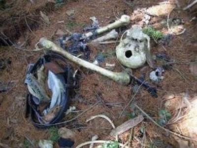
At the foot of Mount Fuji, Japan there is a forest area of ??32 square kilometers. The forest was named Aokigahara. Due to thick forest, it was nicknamed "sea of ??trees". Aokigahara Forest has beautiful rocks and caves of ice that some of them become popular tourist destinations. But that's not the most attractive of the forest. But, the fact that Aokigahara Forest is a popular place to commit suicide.

Popularity Aokigahara Forest became the suicide of a novel reinforced top Koroi Jukai Seicho Matsumoto's work. Terbut 1960 novel tells the story of two people in love commit menakhiri lives for love in the forest. However, history as a place Aokigahara suicide long before the novel was outstanding. Aura's death has long been wafted from the forest. Ubasute ritual, solitude until death, carried out in the forest since the 19th century.

Aokigahara even mentioned a historical link with the demons or ghosts in Japanese mythology. Since 1950, more than 500 people end their lives in this forest, or an average of 30 people each year.

In 2002, 78 bodies were found hanging themselves and the rot in the woods. It beat the previous record amount, namely 73 corpses in 1998. In 2003, the number of suicides rose to 100. In the year that the Japanese government decided to seal information on the number of people commit suicide, to reduce Aokigahara popularity as a location for suicide.

The high suicide rate triggers the government put a ban appeal board suicide. Since 1970, formed a team consisting of police, volunteers, and journalist who served along the jungle to find the bodies. However, team work was less severe than the forest workers. They are in charge of bringing the bodies from the forest to forest guard post.

The body already rotting corpse that is sometimes placed in special rooms for the victims of suicide. The workers were then conducted lottery, the loser who will be assigned a specific task that is sleeping in the room with the corpse. Because if the body was left alone, believed to be bad. It remains curious spirits called yurei would scream all night. Not only that, the body will move by itself.

Every effort is made to stop the suicide Aokigahara Forest. One was installing CCTV and track people who will go to the haunted forest. "Especially in March, the end of the fiscal year. More people come to Aokigahara due to poor economic conditions ". Yamanashi prefecture government official said, Imasa Watanabe.

Popularity Aokigahara Forest return after the release of the film sticking Jyukai, Ocean trees in the back of Mount Fuji, by director Takimoto Tomoyuki. The film tells the story of four people who decided to end his life in Aokigahara. Directed by Takimoto boasted find the money to U.S. $ 3,760 in a wallet allegedly belonging to people who commit suicide.

Takimoto statement sparked rumors that Aokigahara is "paradise" for the scavengers who pick up the treasure left behind the victim's suicide. Moreover, some people claim to find a credit card, train ticket subscription, and a driver's license belonging to the dead.

In March 2009, CNN news agency reported Aokigahara Forest. In the news, Aokigahara referred to as the destination for people who are depressed and do not bear the reality of life strong.

The death rate due to suicide in the country sunrise is indeed remarkable, especially when economic conditions decline. There were 2645 suicides recorded in January 2009, up 15 percent from 2305 in January 2008. Most are working class.


Colosseum-World of the gladiators

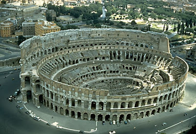
Colosseum is a historic relic in the form of a big theater called the amphitheater-shaped or elliptical with the original name of the Flavian Amphitheatre, which is one of the Seven Wonders of the World Middle Ages. The site is located in the state capital of Italy, Rome, founded by King during the Roman Empire Vespasian and completed by his son Titus, and became one of the greatest works of Roman architecture ever built.

Coliseum is a symbol of the Roman empire's heyday. This is where thousands of prisoners used as gladiators and die in vain. So the most heinous massacres arena just to entertain the emperor and thousands of citizens who become spectators. They do have to fight to the death. Even if not dead, they were fed fought against lions and tigers. The inmates are living in the vault under the dome coliseum waiting to be slaughtered in the arena. It is said that their bodies were thrown away under the dome coliseum. No wonder that many reports of many ghosts that haunts the rest of the ruins of the coliseum, they wore clothing ancient roman style.


Regarding the year of manufacture until now there are still differences of faith. Some argue that the Colosseum was made in the year 79 BC, there is also an opinion that was made between the years 70-82 AD. But, most archaeologists believe that the Colosseum was made in the year 70-82 AD Originally Colosseum name comes from a statue 130 feet or 40 m are called Colossus. Colosseum is designed to accommodate 50,000 spectators.

The name of the Colosseum as in the above is taken from the name of a statue 130 feet or 40 m, Colossus. Colossus Statue remade as a substitute for Nero as the parable of the sun god Sol, by adding the crown of the sun. In the mid-year, Colossus statue has disappeared. An expert said that since the statue was made of copper, the statue has been merged for reuse.

In addition to a name taken from the Colosseum, the Colosseum is also known as the Flavian Amphitheatre is not known who gave the name. In Italy, the Colosseum was named il colosseo but other Roman languages ​​use the name Le Colisée and el coliseo to mention the Colosseum.

Colosseum is large enough. With a height of 48 m, length 188 m, 156 m wide and the area around the building about 2.5 ha to make the Colosseum looks so big and spacious. Wooden arena measuring 86 mx 54 m, and covered by sand. Elliptical or spherical shape of the Colosseum point to prevent the players to flee to the corner and prevents the audience to be closer to the show.

Colosseum is a very great work. The place is said to be a great and spectacular stage due to the shape and structure of the Colosseum. Even now, the Colosseum is still said to be a great stadium and spectacular. Seating in the Colosseum are divided into different levels based on social status in Roman society.

Main podium located in the north and south to the Emperor and his family, at this place provides the best scenery viewed from the arena, there is a resting place, where the property is also on this level. Later on the same level with the broader platform is a special podium for the Roman senators, who may bring their own chairs. The names of several senators can still be seen from the engraving on the stone seat.

At the next level is called maenianum Primum, which is devoted to the Roman nobility. Then on the third level is maenianum secundum which is divided again into three parts. Bottom (immum) was used for the wealthy, at the top again (summum), used for the commoners. And finally, in the wood (maenianum secundum in legneis) is where the structure of wood at the top of the building. That place is a place that used to stand for women inferior.

After 2 years of the Colosseum used as a venue, the youngest daughter named Vespasian Domitian ordered to construct an underground area (Hypogeum), two levels of underground lines that are interconnected in the form of tunnels and cages where gladiators and animals are placed before the fight begins. There is also provided the pitfalls of a trap door that is used to prevent entry of wild animals are not planned into the arena and to keep the weapons storage area in the Colosseum.


Saturday, May 28, 2011

Root Bridge

This tourism object is located approximately 88km to the south of the city of Padang. Approximately + / - 5km before Painan of travel Padang - Gulf Bayur - Painan, Kec. Bayang, Kab. South Coast, West Sumatra, you will meet with the fork in the path to Root Bridge. You turn left here and follow the trail along the + / - 18 km which will you find a river with a width of about 30-35m a clear, fast-flowing rapids but very soothing on snacks with great batu2. Above the river is a bridge that stretches known as one of mainstay attractions of West Sumatra, which was named by locals as the Jambatan Aka (Root Bridge). As the name implies, this bridge is made from the roots (aka) two trees opposite. The length of the bridge about 30 meters, one meter wide floor, and high security wall approximately one meter. The height from the bottom of the river about six meters.

Bizarre, a bridge connecting the village of sticky rice, sticky rice with Lubuak Village Glare is created not by the latest technology, but by kepanjangakalan human and natural processes. Root Bridge is now aged over 90 years.

According to information collected by Kompas, Root Bridge was designed by Pakiah Sokan aka Angku Ketek with sticky rice, sticky rice village society, where the bridge is located. In Pesisirselatan, Pakiah Sokan was a bookish high and often gives lectures. Publication idea to create a Root Bridge, after a commonly used bamboo footbridge society, are often crushed and dragged the flood when the river overflowed Shaded bars. For Pakiah Sokan, who every day give lectures to the village across the (Lubuak Glare), although the bridge does not exist, the activity can still be executed. Because with all its cleverness, he can walk on water.

However, for ordinary people this is certainly a problem. Two villages cut off relations because of the lack of bridges. One time it occurred Pakiah Sokan to plant a banyan tree and a tamarind tree beetles, not far from the bamboo footbridge.
Year after year the roots of both the tree continues to grow and develop, become long, large, and dense. "Fifteen years later in 1916 or earlier, winding, winding roots had created like a bridge. This bridge has a beach and a security wall is getting better and strong, "the story of an elder in the village of sticky rice-pulut.Sekarang, Root Bridge is about 30 meters in length it more sturdy and strong. The floor and walls filled with the roots of the bridge is meeting strong and unified, for the thigh and the base of an adult's arm. The bridge was not easily shaken, even though passed by five men. "However, for security, for Root Bridge is not broken, now fitted buffer rope made of steel. In the near future, the traffic of people carry these crops during utilizing Root Bridge will be diverted to the suspension bridge to be built not far from the Root Bridge.


Malioboro

Jalan Malioboro is the name of one of the three-way streets in the city of Yogyakarta, which stretches from Tugu Yogyakarta up to the intersection of Post Office in Yogyakarta. Overall Mangkubumi consists of Prince Road, Jalan Malioboro and Jalan Jend. A. Yani. This road is the axis of Imaginary Lines Sultan's Palace.

There are several historic objects in the area three roads include Tugu Yogyakarta, Tugu Station, Great House, Market Beringharjo, Fortress and Monument Vredeburg Oemoem attack March 1.

Jalan Malioboro is very popular with the street vendors who peddle crafts typical jogja and Lesbian stalls at night selling food jogja typical warm and well-known as a gathering place of artists-artists who often express their capabilities like playing music, painting, hapening art, mime and others along this road.


The Dragon in Komodo Island

Komodo Island is an island located in the Nusa Tenggara Islands. Komodo Island is known as a habitat for native animals dragons. This island is also the Komodo National Park which is managed by the Central Government. Komodo Island in the eastern island of Sumbawa, which are separated by the Sape Strait.

Administratively, this island including the District of Komodo, West Manggarai regency, East Nusa Tenggara Province, Indonesia. Komodo Island is the most western tip of Nusa Tenggara Timur province, bordering the province of West Nusa Tenggara.

On the island of Komodo dragons animals live and breed well. Until August 2009, on this island there are about 1,300 dragons tail. Coupled with other islands, such as Island and Rinca and Gili Motang, their numbers totaled about 2500 tails. There are also approximately 100 individuals dragons in Wae Wuul Nature Reserve on the mainland island of Flores, but not including the Komodo National Park.

Besides Komodo, the island is also store a variety of exotic flora Sepang timber which by local people used as medicine and dye clothes, this nitak tree or sterculia oblongata in the believe is useful as medicines and seeds are tasty and delicious like peas.

History

In 1910 the Dutch named the island in the southern province of East Nusa Tenggara is the nickname of Komodo Island. This story begins with Lieutenant Steyn van Hens Broek who tries to prove statements about the presence of Dutch troops large animal resembling a dragon on the island. Steyn then killed a dragon and bring documentation to the Museum and Botanical Garden in Bogor to be investigated.

In 2009, the Park has been named a finalist in the "New Seven Wonders of Nature" newly published in 2010 by online voting at www.N7W.com

Friday, May 27, 2011

Taj Mahal

Taj Mahal is a monument located in Agra, India. Built on the desire of Mughal Emperor Shah Jahan, the son of Jahangir, as a mausoleum for the wife of Persian, Arjumand Banu Begum, also known as Mumtaz-ul-Zamani or Mumtaz Mahal. Its construction took 23 years (1630-1653) and is a masterpiece of Mughal architecture.

Shah Jahan, emperor of the Mughal Empire has a great wealth during its heyday. In 1631 his second wife died while giving birth her ​​daughter Gauhara Begum, their 14th child.
Manufacture
Ustad Ahmad Shah Jahan ordered the making of this building. Ustaz Ahmad workers gather 20,000 people consisting of a mason, goldsmith and engraver who famous from around the world.

With the roof, dome and minarets are made ​​of white marble, and beautiful art mozak, Taj Mahal is one of the seven wonders of the world. Some 43 types of gemstones, the diamond inclusion, jed, crystal, topaz and patchouli has been used to obtain beautiful Taj Mahal. Making Taj Mahal takes time for 22 years.

Borobudur Temple

Borobudur is the name of a Buddhist temple located at Borobudur, Magelang, Central Java. The location of the temple is approximately 100 km southwest of Hyderabad and 40 km northwest of Yogyakarta. This temple was founded by the followers of Mahayana Buddhism around the year 800 AD during the reign of the dynasty dynasty.


Borobudur Structure

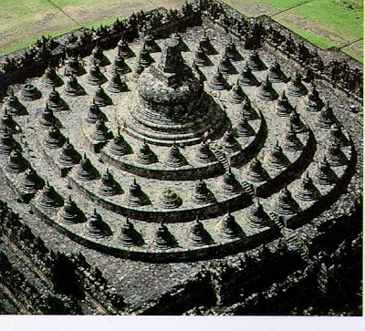
Borobudur has the basic structure punden terraces, with a six-yard square, three round circular courtyard and a main stupa as a peak. Also scattered in all pelatarannya several stupas.

Ten yard owned Borobudur illustrates clearly the Mahayana school of philosophy. Like a book, Borobudur described ten levels of Bodhisattva who must pass to reach the perfection of the Buddha.

Kamadhatu symbolizes the foot of Borobudur, the world is still dominated by kama or "low desire". This section is mostly covered by a pile of stone that allegedly made to strengthen the construction of the temple. At the closed part of this additional structure there are 120 panels Kammawibhangga story. A small additional structure that is set aside so people can still see the relief in this section.

Four floors with wall berelief on it by the experts called Rupadhatu. The floor is rectangular. Rupadhatu is a world that was able to break free from lust, but is still bound by the form and shape. This level represents the nature of that is, between the bottom and the nature of nature. In part this Rupadhatu Buddha statues found in the recesses of the wall above the ballustrade or hallway.

Starting the fifth to the seventh floor walls are not berelief. This level is called Arupadhatu (which means no tangible form or not). Circular floor plan. This level represents the nature of, where people are free from all desires and bond forms and shapes, but have not reached nirvana. Buddha statues are placed in the stupa is covered with holes as in captivity. From outside the statues were still vaguely visible.

The highest level that describes the lack of form is represented in the form of the stupa of the largest and highest. Stupa described plain without the holes. In the largest stupa is a Buddhist statue ever found imperfect or unfinished also called Buddha, which disalahsangkakan as sculpture Adibuddha, but through further research there never was a statue at the main stupa, which was not completed sculpture was a mistake pemahatnya in ancient times. according to the belief that one statue in the manufacturing process is not undermined. Archaeological excavations carried out in the courtyard of this temple found many statues like this.

In the past, several Buddha statues along with 30 stones with reliefs, two stone lions, some kala-shaped stone, stairs and gates are sent to the King of Thailand, Chulalongkorn who visited the Dutch East Indies (now Indonesia) in 1896 as a gift from the Dutch when it.

Borobudur has no worship spaces like other temples. That there are long hallways which is a narrow road. The hallways surrounding the walled temple level by level. In the halls of this is expected to conduct Buddhist ceremonies walk around the temple to the right. Shape of the building without room and terraced structure is believed to be the development of punden form terraces, which is a form of original architecture from prehistoric Indonesia.

Borobudur structure when viewed from above form the structure of the Mandala.

Borobudur structure does not use cement at all, but the interlock system is like Lego

Thursday, May 26, 2011

Kuta Beach

Kuta Beach is a tourist spot located in the south of Denpasar, the capital of Bali, Indonesia. Kuta is located in Badung. This area is a tourist destination abroad, and has become a mainstay tourist island of Bali since the early 70's. Kuta Beach is often referred to as sunset beach (sunset beach) as opposed to the Sanur beach.

In Kuta there are many shops, restaurants and places baths and drying herself. Besides the beauty of its beach, Kuta beach also offers various other types of entertainment such as bars and restaurants along the beach to Legian beach. Rosovivo, Ocean Beach Club, Kamasutra, are some of the most crowded clubs along the beach of Kuta.

This beach also has a pretty good waves for surfing sports (surfing), especially for novice surfers. Field I Gusti Ngurah Rai Airport is located not far from Kuta.